
This now leaves us with no choice but to give the floor to Dr. Maciej Lenartowicz of the UW’s Department of Geography and Regional Studies told us about the special conditions in Kampinos. You can’t miss this interview!
Fruitful reading!
Why is the Kampinos National Park unique in terms of natural heritage in Poland?
The Kampinos National Park was established thanks to the idea of protecting highly diverse ecosystems in the valley of a large European lowland river. Here we see landscape zones where hydrogenic ecosystems, that is, low bogs in depressions in the area, and other types of wetlands , are adjacent to the tops of dunes, which are often extremely dry. It is this contrast at distances of sometimes hundreds of meters that is very valuable here. Another is the issue of the area’s biodiversity and its role in water retention due to the presence of wetlands.
What is particularly protected in the Kampinos Forest?
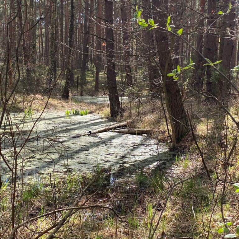
The Kampinos National Park protects ecosystems that are highly sensitive to fluctuations in water resources. Unfortunately, the park is located in a place where there is particular exposure to the effects of climate change and environmental transformation. At times like these, that is, when water resources are limited by the occurrence of lower-than-normal precipitation totals in recent months in Poland, it is observed that some watercourses dry up and the groundwater table drops to a level that becomes dangerous from the perspective of undisturbed functioning of wetland ecosystems.
What is the current hydrological situation in Kampinos?
For many years, research has been conducted here on what is actually happening in the Park in terms of the water cycle. At the end of the first decade of the current century, it was determined what the situation in the Park is now and how it was originally shaped. It was found that the area has been heavily transformed by man. Despite these encroachments, wetland ecosystems have survived, among other things. attempt to adapt the area to the requirements of agricultural use Thus, deforestation, land reclamation or drainage of the wetland area as a result of the blockage of the flood flow from the Vistula River survived.
And what did these areas look like originally?
Interestingly, there were no rivers there at all. This was an area that was a drainless basin, a large one that stretched from present-day Lomianki in the east , to the valley of the Bzura River in the west. This basin was not drained by any permanent watercourses. In addition, it was fed by the Vistula’s flood waters. Vistula waters, when there were high river levels and their volume was very large, did not fit in the Vistula riverbed, overflowed into this basin in the area of present-day Lomianki or Czosnow and fed the wetlands of the Forest, so to speak, “from above.” These waters stagnated in the Kampinos basin, providing an opportunity for peat-forming processes to develop, resulting in the intermittent wetlands and peat bogs that are there now.
What impact does human activity have on the hydrological situation in Kampinos National Park?
On the southern side, the Park is fed by waters from the Łowicko-Błońska Plain, areas that are to the west and southwest of Warsaw. At a time when the Warsaw agglomeration was not yet “spilling over” so intensively in all directions, human activity was not as much of a problem. However, this is currently changing dynamically. When we take a look at what the Park’s border looks like along the road from Warsaw to Sochaczew, we can see how many logistics centers, companies and settlements and what kind of development is going on there. These settlements of houses that are being built there, I call them “concentration settlements” myself, are strings of sectional houses that have taken the place of former farmland. Examples include Stare Babice, Latchorzew or Zielonki, where water relations are being altered in this way. This is because these settlements are built on former arable fields, where there used to be room for rainwater to soak in, which then drained north to the Vistula Valley, specifically to the Warsaw Basin, where the Park and the Kampinos Forest are located. This migration of water was slow but uninterrupted. Unfortunately, the development of all kinds of communication and logistics infrastructure and development that takes place there (induced by the proximity of the Warsaw agglomeration) has caused these areas to cease to be areas that supply water to the edge zone of the Park, between the Warsaw Basin and the Łowicko-Błońska Plain. That’s where water relations have been disrupted.
What was the manifestation of this?
Already about 20 years ago, during my research, I noticed that the springs, which were located on the edge of the Łowicko-Błońska Plain, had begun to disappear. This very area located on the escarpment fed the Park below – at the foot of this escarpment, wetlands, springs, seeps and various other hydrographic features developed. Today they are gone. That is, for the past 20 years, this change has been slowly progressing. It is explained, of course, by the prevailing dry season and various activities, such as water exploitation, which caused the water table to actually drop.
What else affects water levels in the Kampinos?
This disruption of the water cycle has unfortunately been superimposed on the climate change we are seeing globally and the increasingly long series of rainless years, that is, years when precipitation totals are minimal or, at best, below the multi-year average. The park is very diverse in this regard. The eastern part, the one closer to Warsaw, usually receives more precipitation annually, while the western part, for very different reasons, receives less. Perhaps this is a matter of the precipitation shadow of the Plonian Plateau to the north. Or maybe some other reasons, such as the influence of the Warsaw agglomeration, which generates a specific modification of atmospheric circulation? The point here is that we have an urban heat island in Warsaw, which causes hot air masses to rise in the summer – heated concrete and other artificial surfaces in the city trigger convection processes of air masses. Their upward movement may in some cases block moist air masses, usually coming from the west and northwest, which dry out their moisture in the Warsaw foothills. This makes the northwestern districts of Warsaw and the eastern part of the Park more favorable in terms of precipitation. Annually, this can cause as much as more than 100 mm of difference in precipitation, between the eastern part of the park and its western and central portions. This makes it even more difficult to manage the area’s water resources.
So we have the south more or less worked out, but what is the situation in the northern part of Kampinos?
There we have to deal with the immediate vicinity of the Vistula River. Someone might say that such a large river guarantees that there should be no problem iz access to water. Fact, indeed in the northern part of the Park the situation of water resources is better. The only problem is – again – with human activity. The series of floods that hit the entire Vistula basin in the 19th century and early 20th century led to the decision to protect the settlement networks developing around it with floodwalls. This was a great move from the point of view of human activity and protection of human settlements from flooding from the Vistula. For that, it is less beneficial from the side of preserving water-dependent ecosystems, which at the time, of course, no one had yet seriously thought about. So a flood barrier was built along the entire Vistula River, almost perfectly protecting the National Park from the supply of flood waters from the river. Fortunately, the Vistula is such a large enough hydrographic feature that even a rise in water levels in its riverbed causes the groundwater table in its vicinity to rise. That’s why the northern areas of the park have been less affected by drying than the middle and southern parts of the park And that’s why, despite the floodwater cutoff, the water resources situation is not yet so dramatic in the northern part of the park. It’s just important to know that the Vistula’s direct impact on groundwater is not unlimited. By various researchers it is estimated from a few hundred meters to 2 – 3 kilometers.
It is still worth remembering that the last major flood wave passed through the Vistula in 2010 – a long time ago, in fact. We’ve all almost forgotten about it by now. In Lomianki at the time, there was fear and apprehension that the flood barrier would break. Now everyone has forgotten about it, and the development of the former floodplain there has become more dynamic again.
So what conclusions can be drawn from the observations made?
Undoubtedly, the water table in the Kampinos Forest has been declining in recent years, and it happens that many wetlands have been dried up irretrievably. The intermittent wetlands and peatlands that are in the Park have been subjected to long-term processes of drainage and anthropogenic transformation in the form of construction of new drainage ditches, deforestation, in other words, in general, reducing the capacity for rainwater retention and accelerating its runoff. The situation has begun to develop in a very unfavorable direction since 2015, since when we have seen more dry years than average and wet ones.

Dr. Maciej Lenartowicz, Faculty of Geography and Regional Studies, UW
The post is part of a series on natural heritage entitled “How to Live? – Naturally!”, which was created to draw attention to the need to protect the Earth’s natural heritage.
#naturalheritage #worldheritage #ExpertsUW #unesco #natural